ShopDreamUp AI ArtDreamUp
Deviation Actions


Suggested Deviants


Suggested Collections


You Might Like…


Description
(Originally appeared on my tumblr)
(Also I have literally NO IDEA which category I should submit this to... It's digital art but it doesn't feel "conceptual" enough to be conceptual so ummm..... Yeah?)
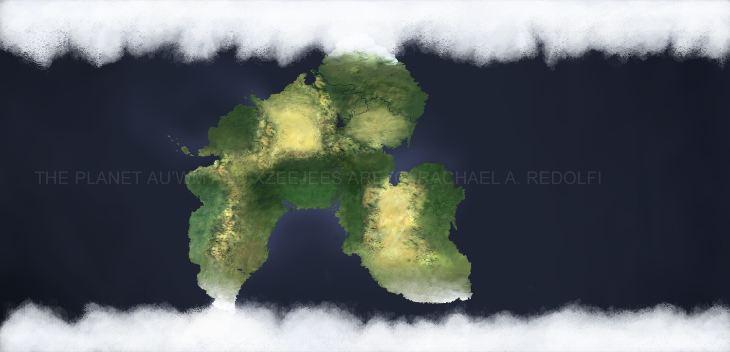
So Au’wm is a near-earth planet inhabited by the Xzeejees. There are actually a lot of different ways to say “Au’wm” depending on which dialect you are speaking, so feel free to pronounce it however feels natural to you.
It’s pretty easy to notice that Au’wm is just one mega-continent. If we’re being honest here about 50% of my decision-making process for the planet of Au’wm was “which concept seems like the most fun to play with” and that includes the idea of a mega-continent.
You’ll notice that there are a lot of mountain-ranges and deserts because mega-continent. The continents are all smooshed together, and that results in a lot of mountains which, in turn, create a lot of rain-shadows.
Next you’ll probably notice the Great Gulf region, and how Au’wm basically looks like an upside-down horse-shoe. Weather-systems from the Great Gulf can travel into the Core of Au’wm (the verycenter part) and thus it possesses the only actual jungles.
Also there are a lot of steppes and plains, again going back to how relatively dry and cool mega-continents tend to be.
Oh and the rivers and lakes that I’ve outlined on this map aren’t the only ones, just the major ones that I have set in my mind.
I know there happen to be a lot of islands throughout the ocean, mostly along different fault-lines but to be honest most of them are so small that I doubt you’d be able to see them from a satellite, so I’ll have to go back and eventually chart them out when I have a bit more patience.
One last point of interest: evolving a culture on a mega-continent is what has allowed Xzeejees to socially evolve a pretty uniform, almost one-world government in a relatively short period of time. You have to learn to get along with your neighboring countries when you are all stuck on the same landmass together, regardless of how huge the landmass is. In early points of the Nan’s formation it was regular for different hemispheres of the continent to duke it out against the other side until they all finally reached a relatively beneficial balance for all parts.
*
I cheated a lot making this map. I scanned in the sketch I had, slapped down some basic color then found some satellite images of earth and used the healing-brush to get higher contrast and basic textures. Then I used a whole bunch of different random brushes to sew it all together and make it feel more cohesive.
(Also I have literally NO IDEA which category I should submit this to... It's digital art but it doesn't feel "conceptual" enough to be conceptual so ummm..... Yeah?)
So Au’wm is a near-earth planet inhabited by the Xzeejees. There are actually a lot of different ways to say “Au’wm” depending on which dialect you are speaking, so feel free to pronounce it however feels natural to you.
It’s pretty easy to notice that Au’wm is just one mega-continent. If we’re being honest here about 50% of my decision-making process for the planet of Au’wm was “which concept seems like the most fun to play with” and that includes the idea of a mega-continent.
You’ll notice that there are a lot of mountain-ranges and deserts because mega-continent. The continents are all smooshed together, and that results in a lot of mountains which, in turn, create a lot of rain-shadows.
Next you’ll probably notice the Great Gulf region, and how Au’wm basically looks like an upside-down horse-shoe. Weather-systems from the Great Gulf can travel into the Core of Au’wm (the verycenter part) and thus it possesses the only actual jungles.
Also there are a lot of steppes and plains, again going back to how relatively dry and cool mega-continents tend to be.
Oh and the rivers and lakes that I’ve outlined on this map aren’t the only ones, just the major ones that I have set in my mind.
I know there happen to be a lot of islands throughout the ocean, mostly along different fault-lines but to be honest most of them are so small that I doubt you’d be able to see them from a satellite, so I’ll have to go back and eventually chart them out when I have a bit more patience.
One last point of interest: evolving a culture on a mega-continent is what has allowed Xzeejees to socially evolve a pretty uniform, almost one-world government in a relatively short period of time. You have to learn to get along with your neighboring countries when you are all stuck on the same landmass together, regardless of how huge the landmass is. In early points of the Nan’s formation it was regular for different hemispheres of the continent to duke it out against the other side until they all finally reached a relatively beneficial balance for all parts.
*
I cheated a lot making this map. I scanned in the sketch I had, slapped down some basic color then found some satellite images of earth and used the healing-brush to get higher contrast and basic textures. Then I used a whole bunch of different random brushes to sew it all together and make it feel more cohesive.
Image size
1500x723px 400.5 KB
© 2014 - 2024 RRedolfi
Comments0
Join the community to add your comment. Already a deviant? Log In